What does GIS mean?

Are you looking for the meanings of GIS? On the following image, you can see major definitions of GIS. If you want, you can also download image file to print, or you can share it with your friend via Facebook, Twitter, Pinterest, Google, etc. To see all meanings of GIS, please scroll down. The full list of definitions is shown in the table below in alphabetical order.

Major Meanings of GIS

The following image presents the most commonly used meanings of GIS. You can down the image file in PNG format for offline use or send it to your friends by email. If you are a webmaster of non-commercial website, please feel free to publish the image of GIS definitions on your website.

What does gis stand for

As previously mentioned, the image associated with the acronym GIS is formatted in PNG, which stands for Portable Network Graphics. This image has specific dimensions, with a length of 669 pixels and a width of 350 pixels. The file size of the image is approximately 60 kilobytes. This format and size are chosen to ensure that the image maintains high quality while remaining efficient in terms of storage and loading times.
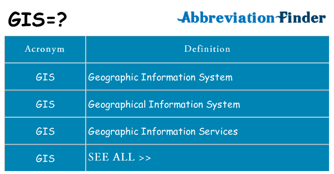
  • Citation as a Visitor
What does GIS mean? This page is about the various possible meanings of the acronym, abbreviation or slang term. If you find this information useful or interesting, please feel free to share it on your favorite social media platforms.
  • Citation as a Webmaster
If you wish for your visitors to access a comprehensive list of all possible meanings of the acronym GIS, it is recommended that you incorporate the acronym into your bibliography using proper citation formats.

All Definitions of GIS

As mentioned above, you will see all meanings of GIS in the following table. Please know that all definitions are listed in alphabetical order. You can click links on the right to see detailed information of each definition, including definitions in English and your local language.
AcronymDefinition
GISGarden International School
GISGas Insulated Substation
GISGas Insulation System
GISGas-Insulated Switchgear
GISGastrointestinal Series
GISGeeky Internal Stuff
GISGeneral Information Services
GISGeneral Information Session
GISGeneral Investigative Section
GISGeneralized Iterative Scaling
GISGenome Institute of Singapore
GISGentran Integration Suite
GISGeodata Interoperability Specification
GISGeografisch Informatie Systeem
GISGeographic Imaging Solutions
GISGeographic Information Services
GISGeographic Information Solutions
GISGeographic Information Studies
GISGeographic Information System
GISGeographical Imaging Software
GISGeographical Information Science
GISGeographical Information Services
GISGeographical Information System
GISGeographical Intelligent Survey
GISGeographisches Informationssystem
GISGeophysical Information System
GISGeoreferenced Information System
GISGeoscience Information Society
GISGeospatial Information System
GISGeosynchronous Meteorological Satellite
GISGhana International School
GISGisborne, New Zealand
GISGlobal Inbound Service
GISGlobal Indexing System
GISGlobal Information Society
GISGlobal Information Solutions
GISGlobal Infrastructure Services
GISGlobal Insight Services
GISGlobal Investment Systems
GISGlobal and International Studies
GISGoddard Information System
GISGolisano Institute for Sustainability
GISGoogle Image Search
GISGovernment Information System
GISGraphics Information System
GISGreatness Is Simplicity
GISGreen Iguana Society
GISGroup Index and Schedule
GISGroup Information Session
GISGroup Interference Suppression
GISGroupe Interventional Speciale
GISGroupement d'Intérêt Scientifique
GISGruppo d' Intervento Speciale
GISGuaranteed Income Supplement
GISGuidelines Implementation Staff
GISGunbound International Server
GISGussoh Imagesystem

This page illustrates how GIS is used in messaging and chat forums, in addition to social networking software like VK, Instagram, Whatsapp, and Snapchat. From the table above, you can view all meanings of GIS: some are educational terms, the other are medical terms, and even computer terms. If you know of another definition of GIS, please contact us. We will include it during next update of our database.

GIS as an Acronym

In summary, GIS is an abbreviation that can stand for various terms depending on the context, and its interpretation can vary across different fields such as technology, business, education, geography, government, law and other specialized areas. If you have more interpretations or meanings for this acronym, we encourage you to contact us and share them, as understanding the diverse uses of abbreviations like GIS helps in better communication and comprehension across various fields.
  • Advantage of Using Acronym GIS
Using GIS as an acronym offers efficiency and brevity, saving time and space in communication while conveying professionalism and expertise within specific industries. The use of acronym acts as memory aids and maintain a consistent tone in documentation.
  • Disadvantage of Using Acronym GIS
Because GIS has multiple meanings, this acronym can be ambiguous, leading to confusion if it is unfamiliar to the audience. Using acronym can also create exclusivity, potentially alienating those not versed in the jargon, and excessive use can reduce clarity.